Matthews-Winters Park Gets Designated Mountain Bike Only Trail

Reprinted from Jeffco Open Space News Release, October 28, 2019

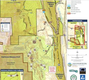
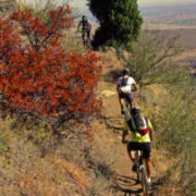
After conducting a one-year pilot program on the newly constructed Dakota Ridge South Trail at Matthews/Winters Park, Jeffco Open Space is officially designating the .8 mile section of Dakota Ridge South Trail as mountain bike only, as of November 1, 2019.

The 2018 Jeffco Resident Survey reflected that 75% of respondents were in favor of designating trails for a single type of use. In addition, the 2014-2019 JCOS Master Plan identifies the objective to evaluate different management types on existing trails. Considering these factors, along with additional considerations, JCOS decided to implement a pilot program to evaluate designated use trails.

The pilot program evaluated the challenges and benefits associated with designated use trails. During this time, Jeffco Open Space collected data, conducted surveys with all visitor types, and solicited feedback about visitors’ overall experience on the trail.

Approximately 80% of all visitors surveyed were satisfied or in favor of the designation for the Dakota Ridge South Trail. Jeffco Open Space also collaborated with the regional mountain bike community, who provided valuable insight and feedback. Based on this data and positive comments collected from visitors, Jeffco Open Space made the decision to make the designation permanent.

Dakota Ridge South Trail will go from a pilot program to a mountain bike only designation on November 1, 2019 and will be signed to reflect this change.

To learn more about designated use trails in Jeffco Open Space parks, visit www.jeffco.us/3817/Designated-Use.

Matthews Winters Open Space Park map


Jeffco Open Space was founded as a land conservation organization in 1972. Our mission is to preserve open space and parkland, protect park and natural resources, and provide healthy, nature-based experiences. Funded with a one-half of one percent sales tax, our organization contributes to city and park district projects, has preserved more than 56,000 acres, and manages 27 open space parks and more than 244 miles of trails in Jefferson County, Colorado.

For more information contact: Matt Robbins, Community Connections Manager, mrobbins@jeffco.us or 303.271.5902


Colorado Pollinator Summit Nov. 1 at CU Boulder

Not everything we post is about Jefferson County Open Space. For instance, the 2019 Pollinator Summit is an event you may want to check out if you have an interest in wildscaping your neighborhood.

Yes, even if you live in the city, you can enjoy the benefits of a wildscaped environment in your own back yard! Come and find out how it’s done!

Fourth Annual Colorado Pollinator Summit
Friday, Nov 1, 2019, 8 am-4:30 pm; $45

Sustainability, Energy, & Environment Center
CU Boulder East Campus, 4001 Discovery Drive
Boulder, CO 80303

Morning talks and panels will feature the theme of “Protecting Colorado’s Biodiversity” through

models for wildscaping urban neighborhoods, landscaping for biodiversity, and regenerating land through holistic farming-all with a Colorado focus. Kate Greenberg, Colorado Commissioner of Agriculture, will give opening remarks.

The afternoon will include a participatory format and short inspiring talks to spur breakthrough thinking and action.

Register now. Past summits have sold out in advance. Registration includes lunch and refreshments. Discount rates available for students.

https://tickets.butterflies.org/DateSelection.aspx?item=491

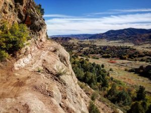
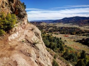
The section on the Black Bear Trail called The Ledge is for adventurous hikers and bicyclists. Photo by Nathan McBride

Rugged New Black Bear Trail for Advanced Users Only

By Vicky Gits

The section on the Black Bear Trail called The Ledge is for adventurous hikers and bicyclists. Photo by Nathan McBride

With 65 switchbacks in only 6.3 miles and a stunning cliff feature with a 50-foot drop, the new Black Bear Trail is one of the most challenging in the Jefferson County Open Space park system.

The trail connects two parks in South Jeffco, Deer Creek Canyon and Hildebrand Ranch. (For details see map at jeffco.us/parks, Deer Creek Canyon Park)

The Black Bear trail gets its name from the first attempt to build it in 1994, when workers on the downhill leg into Mill Creek at the time saw a black bear.

Later that year, trail construction came to an unexpected halt when an easement deal around the hogback near Hildebrand fell through. Twenty years later, Open Space revisited the idea of completing the trail, but on a different path.

Construction began Oct. 2016. Most of the work was in summer 2017. The trail opened in 2018.

The route starts near the summit of Plymouth Mountain and goes east, across two hogbacks, mostly downhill to Hildebrand Ranch trailhead.

The trail is open now but is closed seasonally for nesting raptors from Feb. 1 to July 31.

“Not for the squeamish”
Courtesy of Jeffco Open Space.

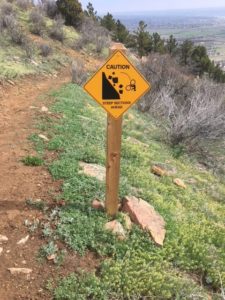
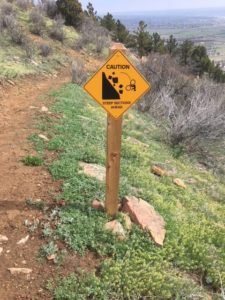
Sign on Black Bear Trail alerts bicyclists to dangerously exposed area known as The Ledge.

“When it first opened, people were pretty much amazed by it, especially when they hit the area called The Ledge,” said Jason Crum, Trails Team Lead, South Region.

The stretch that comprises the ledge is naked rock, no trees and nothing to halt a falling hiker or bicycle, as a warning sign amply illustrates. The Ledge looks precarious in photos, but is manageable at least 3- to 4-feet wide and is less steep and more sustainable than the alternative, Crum said.

It’s not all about The Ledge, though. Jeffco outdoor writer ] Steve Knapp said he appreciates the ecological and geological variety. “From dense pine forests you pass through high meadow before beginning to climb the first of two low hogbacks that stand in the way of Hildebrand.

“These two ridges offer a taste of high prairie, well-seasoned with flavors of the Southwest.  Climbing the first ridge, the trail passes along a lofty stone ledge that, while not for the squeamish is unique within the JCOS system,” Knapp said.

The construction team consisted of about 10 people per day and included members of the Jefferson County Trail Stewardship Team, Team Works and the Mile High Youth Corps.

50 to 60 percent of steep

“The most difficult aspect of the build was the steepness of the side slope,” Crum said. “We shot anywhere from 50 to 60 percent (steepness) on up.” But with so many switchbacks the trail averages only about 10 percent grade, which is a system standard.

Another challenge was chewing through hogback bedrock. “We had to use a thing called Boulder Blaster, which uses water to fracture the rock, and a lot of jack-hammering,” Crum sai

No bailing out

Black Bear is not for the beginning hiker.  It is rated difficult or black diamond in the park system’s rating system, primarily because it’s so long.

Endurance is the main issue, especially if it’s hot weather.  Once you commit, there is no place to bail out, Crum said.

It’s about a 10-mile trip to make the circle from Hildebrand Ranch to Plymouth Mountain and Deer Creek Canyon Park.  But many hikers start at Hildebrand, which entails a 15.8-mile journey to the start of Black Bear at the top of the mountain and back again. Hikers can save a couple of miles by staying on the road.
Courtesy of Jeffco Open Space

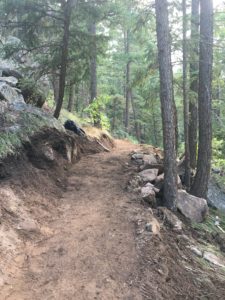
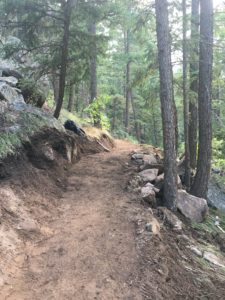
The Black Bear Trail travels through various ecosystems.

Black Bear Trail, a serious workout for bikers, hikers and especially the adventurous, but with plenty to offer the energetic nature-lover, as well.

********

TIMELINE

Black Bear Trail

Connecting Hildebrand Ranch Park to Deer Creek Canyon Park

Jefferson County Open Space

1994: Black Bear Trail built from Plymouth Mountain to Mill Creek and terminated at the second hogback from top. Trail is open to public but seldom used.

Oct. 2016: Construction begins again

Summer 2018: Trail opens for mountain bikes, hikers and equestrians


TRAIL FACTS

Info and Map:  jeffco.us/parks, Hildebrand Ranch Park and Deer Creek Canyon Park. See both maps before setting out on hike.

65 switchbacks

6.3 miles length

6800 feet elevation at start on mountain

5750 feet elevation at Hildebrand Trailhead

10 percent average grade of trail

50 to 60 percent average grade of slope (90 to 100 percent is a vertical wall)

Surface and width: natural surface, 3 to 4 feet wide

The Ledge: 2.1 miles from the start of Black Bear Trail and Two Brands Trail to The Ledge

4,071 feet of chain link fence removed

3,443 feet of installed wildlife friendly HTF range fence

The wildlife-friendly fence is 3 ½ ft. tall with six strands of smooth wire vs. chain link fence that is 6 ft. tall. The wildlife fence is designed to allow easier movement for animals.

2,885 feet of installed chain link fence

4.8 miles of trail on Open Space property

1.5 miles on Lockheed Martin property using and easement agreement (mostly contained by new fence)

2.6 miles of trail built by contractor Arrowhead Trail

3.7 miles built by Jeffco Open Space
UN Biodiversity Report Says One Million Species are at Risk of Extinction

Photo courtesy of Andrew DuBois

Overpopulation, Biodiversity, and Climate Change. It is all linked together and none of it is going in the right direction. That was my take-home message from the United Nations’ Report on Biodiversity released last week.

The report, a three-year effort produced by 150 expert authors representing 50 countries, estimated that over one million species – about one in four – may go extinct in the next several decades unless transformative change happens in human society.

According to the report, the five leading causes of this stark decline in biodiversity are habitat loss, direct exploitation of organisms, climate change, pollution and invasive species. The bottom line is that human populations are ever-growing (as are human appetites for stuff) such that humans are gobbling up native ecosystems to meet expanding needs (and wants). For instance, 75% of the earth’s land surface has been significantly altered (think wild lands are now crop lands), 66% of the oceans are affected (think warmer temperatures, plastic pollution), and more than 85% of wetlands area is lost (think bulldozers).

Besides the fact that destroying a million species that co-inhabit this planet seems morally reprehensible, major biodiversity declines affect human sustainability and welfare in all sorts of ways. For instance, without the buffering capacity of natural ecosystems our food and water supplies are vulnerable. Reduced genetic diversity leaves our croplands vulnerable to disease, drought, or other stressors. Major damage to wetlands and oceans, ecosystems on which many of our food species depend, may leave us without sustainable food sources. “The biosphere, upon which humanity as a whole depends, is being altered to an unparalleled degree across all spatial scales.”

It also turns out that, just as the case with climate change impacts, the impacts of biodiversity losses will be felt disproportionately by the world’s indigenous peoples and the world’s poorest peoples, both of whom are the least responsible for this mess.

Over the past 50 years, human population has doubled and the global economy has grown over four-fold, driving up demands for energy and materials and driving down biodiversity. The only way to break this cycle is to institute transformative changes to our society that will result in sustainable use of resources. This means, for instance, rethinking definitions of success and related incentive structure: stop measuring success by GDP and start measuring it by ecological footprint; provide incentives for biodiversity friendly agricultural practices and habitat restoration and remove incentives for extracting fossil fuels and cutting down forests.

Boiling it down, it means that we need to stem population growth and start recognizing the immense value of natural lands and waters to human life and global sustainability. We need to stop thinking that technology will solve this problem and begin listening to (and replicating) indigenous peoples whose lands are generally in better condition and lifestyles are more sustainable overall than ours. And we better hurry.

Open Space hires deputy director

Hillary Merritt, senior project manager with the Trust for Public Land’s Denver office, has been named deputy director of the Jefferson County Open Space Department. Her main responsibility will be land acquisitions. Open Space Executive Director Tom Hoby announced the decision on Thursday, May 2, at a meeting of the Open Space Advisory Committee. Her first day on the job will be June 17.

Recently Merritt worked with Open Space and other partners to acquire the Applewood Golf Course (which is now part of the Prospect Park & Rec District) and North Floyd Hill (now a  MALT property). She is currently working on two other acquisitions in Jeffco, Hoby said. Over the past 14 years while at TPL, Hillary has developed numerous conservation partnerships around the Denver area, state and region that have led to preserving over 7,000 acres of land.

Previously, she worked for the Conservation Resource Center and Colorado Conservation Trust in Boulder.

Merritt’s education includes a Bachelor’s degree from Skidmore College and a law degree from the University of Colorado Law School, Boulder. A native Coloradan, she grew up in Aspen and enjoys hiking, skiing, and gardening.

As deputy director, her main responsibilities will include developing and coordinating the land conservation program and landowner relations, expanding existing and developing new partnerships, assisting with standards and procedures, policy formulation and strategic initiatives.

With 30 offices nationwide, The Trust for Public Land helps communities raise funds, conduct research and planning, acquire and protect land, and design and renovate parks, playgrounds, trails, and gardens.

Class-1 e-bikes allowed at Open Space Parks

After one year on a trial basis, Jeffco Open Space revealed Oct. 23 that some power-assisted bicycles would be allowed on all trails, according to a report in the Evergreen Canyon Courier. JCOS previously has experimented with allowing bikes on paved trails and bikeways as well as natural surface trails.

Class 1 is the lowest of three classes of e-bikes and is motorized only when the rider is pedaling. The top speed allowed with assistance is 20 mph.

Mary Ann Bonnell, visitors service manager, unveiled the decision at a staff briefing with commissioners, according to the Courier. Of the 59 comments about bikes, 54 percent were positive, 29 percent neutral and 17 percent negative.

Update: March 2019, Open Space will permit Class 1 E-bikes on all trails and Class 2 E-bikes on paved trails.


U.S. legislators propose to save 400,000 acres in Colorado

Mount Sneffels in the autumn. The CORE Act would preserve this beautiful mountain.

Sen. Michael Bennet and Rep. Joe Neguse, both Democrats, jointly plan to propose legislation in Congress on Monday, January 28, 2019, to preserve 400,000 acres, including 29,000 in the area around Camp Hale.

In southwest Colorado, the act would protect nearly 61,000 acres of the San Juan range and would designate a number of the area’s highest peaks, including fourteeners Mount Sneffels and Wilson Peak, as wilderness.

Named the Colorado Outdoor Recreation and Economy Act or CORE, it also designates as wilderness nearly 32,000 acres near Telluride, Norwood, Ouray and Ridgway.

The Denver Post posted the article on its website in the afternoon of Jan. 25.  https://www.denverpost.com/2019/01/25/bill-preserve-colorado-public-lands-michael-bennet-joe-neguse/