Jefferson Parkway Update

by Richard Sugg

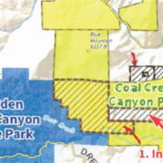
In July of 2015 the Colorado Department of Transportation (CDOT) told the WestConnect Coalition Steering Committee that the proposed 10.5 mile Jefferson Parkway (JP) toll road is a privately funded project. The Coalition’s members include Jefferson County, City of Arvada, City and County of Broomfield, City of Golden, City of Lakewood, and Town of Morrison. The Coalition was formed to study options for completing a “Western Beltway” that includes segments from C-470 in Golden along the SH-93 corridor and through north Jeffco to the NW Parkway. Since the inception of the JP project the Jefferson Parkway Public Highway Authority (JPPHA); whose members are Jefferson County, Arvada, and City and County of Broomfield; have said that it would be built by private investors and that state taxpayer money would not be used for the new highway. Most new lanes in Colorado will have to be paid for with toll revenue; if that is not sufficient, additional money will have to be raised from bonds, new taxes and/or fees. Because of a very low projection of traffic volume the JPPHA and prospective private bidders concluded that toll revenue will not come close to paying for the project, such that additional sources of money will be required to implement it.

The Charter for the WestConnect Corridor Coalition states its Purpose is “to improve mobility for the C-470 (Segment 2), 6th Avenue, State Highway 93, Jefferson Parkway, and Interlocken Loop Corridors from Kipling Parkway to Northwest Parkway.” The length of the corridor from C-470 through Golden via US-6 and SH-93 to the west end of the NW Parkway is 26.5 miles, of which the proposed JP toll road is 10.5 miles. Adding new lanes including the JP and improving intersections on that 26.5 mile corridor would close the “gap”” in a complete Denver Beltway, the goal of the Jeffco-led WestConnect project. In January, 2012 a CDOT representative reported that “CDOT has other priorities” than completing the beltway through Golden. CDOT is supporting WestConnect and paying the most ($1.6 million) for the Western Beltway Study.

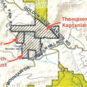
The initial Jeffco website introduction to WestConnect was, “the County’s desire to facilitate construction of the Jefferson Parkway [toll road].” CDOT policy requires that managed/tolled lanes be considered when new lanes are needed to increase capacity on “state highways that are or will become congested.” Other segments of the proposed Western Beltway will be widened by adding a toll lane in each direction; the four lanes of the JP would be all new toll lanes. Much of C-470 meets the criteria for adding tolled lanes, as does US-36 between Denver and Boulder. However, there is no current or projected congestion along the route proposed for the JP toll road in Jeffco that requires an increase in capacity. Free SH-93, SH-72, SH-128 and Indiana can get drivers anywhere that the JP could and are not congested, except for current rush hour traffic on SH-93. Also, the JP will have no parallel free lanes and no free use of tolled lanes by HOV-3 vehicles or buses like those for the added managed/tolled lanes on US-36 and C-470.

The Jeffco County Wide Transportation Plan (CWTP) has called for widening Indiana to four lanes since 1998. The 2000 Report of the NW Quadrant Transportation Feasibility Study concluded that a single high-speed, limited access highway through northern Jefferson County and Golden was not needed to meet the demands of future traffic and that improving existing arterials would be better and more cost-effective. All three JPPHA partners approved the recommendation of the NW Quadrant Transportation Feasibility Study to widen Indiana and SH-93 to four lanes. That increase in capacity on an Indiana alternative to the JP toll road, however, will not happen if the JP is built as proposed. As the planned JP route along the east side of Rocky Flats is parallel to Indiana, and Arvada and Broomfield do not plan to widen free Indiana to compete with the toll road.

The 2014 CWTP does not describe the JP as a “Needs Based Project.” There would be no access from the JP to the fast growing Arvada communities of Leyden Rock, Leyden Ranch, and the residential section of Candelas. There are already four entrances to Candelas off the nontolled SH-72. The JPPHA has said that building the toll road would provide an improved route between Golden and Boulder. However, it is questionable that drivers would leave SH-93 that has no tolls, to go onto the JP that would be tolled and then drive miles out of the way to a congested and tolled US-36 to reach Boulder. The Jefferson Economic Council produced a study pointing out how building the JP would produce great economic wealth for northern Jeffco; the study said nothing about economic growth without the JP. The study also was based on the incorrect assumption that the JP would not be a tolled road.

Local Park and Nonprofit Grants

The December OSAC meeting was devoted to hearing presentations from cities, park districts, and non-profits to receive grants in 2016. The grants then were discussed during the January meeting Study Session and then considered for approval at the January Regular meeting.

There was $453,000 available for grants from the Jefferson County Conservation Trust Fund (Colorado Lottery Proceeds). The grants approved by OSAC and later by the Commissioners included:

Evergreen Audubon Society

Evergreen Nature Center. $9,000 – Improvements (new heater).

Friends of Dinosaur Ridge

Dinosaur Ridge. $20,000 – West Entry sign.

Buffalo Park Improvement Association

$8,000 – resurfacing Buffalo Creek trailhead parking lot, a major trailhead for the Pike National Forest trails.

Beaver Ranch

$20,000 – Implementation of 1st Phase of Master Plan. Priority will be selected when the plan is completed. Have $25,000 remaining from the 2015 grant as National Park Service is doing the Master Plan.

City of Lakewood

Carmody Park Phase I additional amenities. $265,000, Second year of funding for remodel of Carmody Park including an accessible playground. Note that GOCO also gave Lakewood a grant for Carmody Park in 2016.

City of Wheat Ridge

$88,000 – Picnic Shelters along Clear Creek Trail.

Ken-Caryl Ranch Metropolitan District

$43,000 – Community Center Outdoor Restrooms; hikers, tennis players, and playground users do not have to come into the Community Center.

The funds available for 2016 Local Park and Recreation Grants Funded with Jefferson County Open Space Sales Tax Fund totaled $1,200,000. The grants approved by OSAC included:

City of Arvada

Terrace Park Renovations. $200,000 – Trail Connection. This is an underdeveloped and underused park between Carr, Estes, 53rd Ave and the railroad tracks. Total project is $653,000 and includes trail, fitness stations, shelters, lighting, etc.

Apex Park & Recreation District

$430,000 – Final Phase of Simms Street Center Pickleball Courts and Demonstration Garden. This adds 8 more pickleball courts (bring the total to 16) and landscaping around the court area. Apex will not be eligible for a new grant until 2019.

Evergreen Park & Recreation District

$95,000 – Marshdale Park Improvements; will replace 20-year old playground equipment and centralize the equipment.

Foothill Park & Recreation District

$300,000 – Clement Park Renovations (from the 2016 budget Balance, $2,700,000, from JCOS reserves and Foothills will not be eligible for a new grant until 2027.)

Clement Park was developed about 30 years ago by JCOS and leased to Foothills. The contract specifications for the development were less than they should have been. Ground settling has caused breaks in the irrigation system, settling of buildings (up to 8 or 9 inches), corrosion of the lamp posts. Foothills did a Master Plan for the park that indicated up to $20,000,000 was required to implement. JCOS asked for an estimate of what was required to make the present facilities sustainable. Foothills came up with about $6,000,000 in immediate needs. They had some Certificates of Participation (COP’s) expiring such that they could issue $3,000,000 in new COP’s.

Renovations include:

1) replacing the core building (at the ballfield complex), the fountain, and plaza;

2) improvements at the amphitheater including widening of the walks to allow vehicle access without driving on the grass;

3) replacing most of the road and parking lighting;

4) restoration of the restroom adjacent to the tennis courts;

5) level and re-sod field 5 to make it rentable;

6) Johnson Lake stabilization of the North bank and general clean up so it could be used for boating; and

7) replace the present playground with a destination style playground near the shelters. Note that GOCO has given Foothills a grant for the fountain replacement.

Prospect Recreation & Park District

$100,000 – Applewood Golf Course Acquisition (from the 2016 budget if negotiations with Molson-Coors are successful. Balance, $1,000,000, from the JCOS fund balance. Prospect would not be eligible for a new grant until 2027.)

The grant to Prospect was approved by OSAC but the Commissioners chose to table it pending the results of the negotiations with Molson-Coors.

The above grants were all approved by the Commissioners.

Coal Creek Canyon Park Expansion

On December 15, 2011 Open Space closed on the 613-acre Booth-Rogers property. The Northeast portion of the property is adjacent to the undeveloped Coal Creek Canyon Park and the South boundary connected to White Ranch Park via two trail easements. The property at one time was much larger and served as a cattle ranch. It had been in the Booth family for 127 years. In the early days, a wagon road passed through the property as an alternate route from Denver and Boulder to Central City. Open Space had an easement on 619 acres adjacent to the west of the property which is adjacent to Golden Gate Canyon State Park, see map.

The easement, a 344 acre strip through the center of the Booth-Rogers property, and 119 acres adjacent to the north of the property were owned by a single ownership who were planning development. After years of negotiation, Open Space was able to get the ownership to agree to sell all but a 10-acre buffer around some ranch buildings on the North piece.

The sale was completed early this year and adds 1076 acres to Coal Creek Canyon Park. Most of the 1689 acres represented by the two purchases are South-facing slope that is moderately wooded, with large meadows, some springs and ponds. Wildlife is abundant.

The property is part of the Ralston Creek Uplands. Comments from the 2011 study by the Colorado Natural Heritage program. The rugged uplands are covered largely with forests and woodlands and include steep granite outcrops. The forest can be extremely dense in places (a sign of past logging), but has been thinned out in others due to spruce bud worm and pine beetle kills. The areas that are less densely forested have a more diverse understory and herbaceous layer. Ponderosa pine (Pinus ponderosa) and Douglas-fir (Pseudotsuga menziesii) are dominant tree species on the steep and rocky slopes. In some areas the ponderosa pines form savannahs that include spike fescue grass (Leucopoa kingii) forming a rare plant community in the southern section of the site. Common shrubs include mountain mahogany (Cercocarpus montanus), Rocky Mountain juniper (Juniperus scopulorum), common juniper (Juniperus communis), Boulder raspberry (Oreobatus deliciosus) and wax currant (Ribes cereum). The shrublands also contain rare plant communities dominated by mountain mahogany and needle-and-thread grass (Hesperostipa comata). Rocky Mountain juniper (Juniperus scopulorum) and mountain mahogany (Cercocarpus montanus) dominate large sections forming a matrix with ponderosa pine, Douglas-fir and very healthy and diverse native grassland communities.

Road access is difficult as the Brumm Trail from the East is very narrow and steep. Alternate access from Highway 72 on the North is by an access easement limited to maintenance vehicles.

… visit the Coal Creek Canyon Park page » 

Save the Dates for In Plein Sight – Art in Open Air for Jeffco Open Spaces

The preparations for the In Plein Sight series of events this September and October are proceeding rapidly. We are anticipating up to 27 artists painting in Jefferson County Open Space during the week of October 4 to 8.

The week of painting will be proceeded by a three week exhibit of paintings of Jefferson County Open Space parks from a private collection in the Government Center Rotunda.

The paintings by the Plein Air artists will be available for viewing and purchase at the Golden Community Center on October 8 and 9.

PLAN Jeffco will be previewing the events with a booth or information at:

  June 9, 2016   Taste of the West
Jeffco Fairgrounds
  July 16 – 17, 2016   Summerfest
Center for the Arts, Evergreen –
  August 6, 2016   A Night in the Park (MALT)
  August 20 – 21, 2016   Golden Chamber of Commerce Arts Festival
11th Street, Golden
  August 27 – 28, 2016   Evergreen Fine Arts Festival
Evergreen
  September 17 – 18, 2016   Golden Giddyup
Lions Park, Golden

Plein Air painting opening event:

The ‘In Plein Sight’ events begins with the display of a private collector’s commissioned paintings of Jefferson County Open Space Parks in the County Administration Building Rotunda. The display will open the afternoon of September 19 with a reception and will remain available for viewing weekdays through October 7.

Plein Aire painting at Mount Falcon, Moonlight by Don Hamilton - click to enlarge Plein Aire painting at Lair o the Bear Park, Early Autumn by Don Hamilton - click to enlarge Plein Aire painting, Autumn Afternoon by Don Hamilton - click to enlarge

Plein Air painting in the parks will begin October 4, from dawn to dusk:

Tuesday, October 4, 2016

Plein air painting at

South Valley Park

click for park info & map »

Wednesday, October 5, 2016

Plein air painting at

Mount Falcon Park

click for park info & map »

Thursday, October 6, 2016

Plein air painting at

Crown Hill Park

click for park info & map »

Friday, October 7, 2016

Plein air painting at

White Ranch Park

click for park info & map »

Saturday, October 8, 2016

Plein air painting along

Clear Creek Trail in Golden

(from the Washington Street Bridge into Clear Creek Canyon)

click for park info & map »

The finished paintings will be available for viewing and purchase in the Clear Creek and Coal Creek Rooms on the Second Floor of the Golden Community Center on October 8 and 9.

The PLAN Jeffco Board of Director’s thank the following businesses, organizations, and individuals who have become sponsors to date:

Martin Marietta

240 Union

Kentwood City Properties – Ann Lenane & Angela Beldy

First Bank

Holley, Albertson & Polk PC

Applewood Plumbing, Heating & Electric

LIV Sotheby’s International Realty

Bandimere Speedway

Pickard & Ross PC

Tueller & Gibbs, LLP

Onsight Public Affairs

Mount Vernon Data Systems

Jeffco Outdoors Foundation

Denver Mountain Parks Foundation

The Tuesday Birders

Jefferson County Nature Association

William K. Coors

Greg & Sue Stevinson

Joe & Gail Coors

Jan & Ross Wilkins

Margot & Richard Zallen

Maryanne Bach Andrie

Paige & William Alread

Beverly Lipman

Bob & Margie Howe

Nancy & George Crego

T.J. & Deb Carney

Kitty & Rock Pring

Dana Jacobsen

Ann & Mike Moore

Rachel & Andrew Price

Cindy Estrada & Ned Connolly

Liz Wald & Wayne Forman

Ralph Morgenweck

Steve Hoffman

Ken Morfit

Elizabeth Moore

Michael Lancaster

The PLAN Jeffco Board of Director’s also thank the following organizations that so far have offered to assist us in disseminating information about the events:

Clear Creek Land Conservancy

Colorado Open Lands

ENABLE

Evergreen Artists Association

Center for the Arts Evergreen

Foothills Arts Center

Foothills Running and Cycling Club

Golden Giddyup

Golden Chamber of Commerce

Mountain Area Land Trust

Colorado Native Plant Society

Trust for Public Land

American Association of University Women

Audubon Society

Tuesday Birders

Jeffco League of Women Voters

Mount Vernon Country Club

Harmony Village HOA

Ruby Ranch HOA

Governor’s Ranch HOA

Ridge HOA

COHOPE

Just Around Here

Golden Newsletter 

Douglas Mountain Acquisitions

by John Litz

By the end of 2015, Jefferson County Open Space will have closed on three parcels of land totaling 1,036 acres that include the summit of Douglas Mountain. The map shows that most of the three properties are located west of the intersection of Golden Gate Canyon and Robinson Hill Roads. The small acreage to the north of the intersection contains the Centennial House, which was built of stone between 1872 and 1876. The building served as a stage stop for travelers along the historic Gregory Toll Road between Golden and Central City.

PLAN Jeffco has advocated for the acquisition of properties on Douglas Mountain for more than 20 years. We are pleased that the owners have allowed Open Space to preserve them.

The upper slopes of the southern part of the property have numerous locations that provide scenic views to the east and south – Mount Tom and Centennial Cone. The northeast side of the property is adjacent to 573 acres owned by Open Space that abuts the wildlife preserve portion of Golden Gate State Park. The southern boundary is about one mile north of Centennial Cone Park.

Douglas Mountain Acquisitions - heartleaf arnica (Arnica cordifolia)The property is part of the ecosystem that contains drainage to both Clear Creek and Ralston Creek. Parts of the ecosystem were included in the “2010-2011 Survey of Critical Biological Resources in Jefferson County by the Colorado Natural Heritage Program”. The property on the west, Blackhawk Mountain, is forested with Douglas fir and aspen and supports a small, montane grassland. It was rated at “B-5 – General Biodiversity.” The property to the east, Mount Tom, supports limber pine, ponderosa pine, lodgepole pine, and Douglas fir. It was rated “B-3 – High Biodiversity.” The southern extent of the Douglas Mountain property was certified for the previous owners, through the American Tree Farm System, as a sustainable Tree Farm. A site visit by Open Space staff identified heartleaf arnica (Arnica cordifolia), which is an indicator of a healthy, highly functioning ecosystem.

The properties are included in the North Mountain Community Plan, which recommends preserving as much open space as possible, especially along the Golden Gate Canyon Road Corridor. The Plan also recommends diffusing the impacts of recreational development throughout the area. Public access probably will be from points on both Golden Gate Canyon and Robinson Hill Roads.

Open Space will take two years or so to study and understand the natural resources on the property. Then the planning group will look at the recreational possibilities of the property. Any development, probably, is at least five years away. 

Trails Talk (December 2015)

by John Litz

The Fall Trails Talk was held November 10 at the Buchanan Recreation Center in Bergen Park.

Unfortunately the attendance was poor with more staff there than public.

Tom Hoby opened with a quick review of accomplishments over the summer (mainly completing the repair of the flood damage with the help of many volunteers.) He also discussed the climbing management guidelines, the revised activity permits, and the results of surveys where designated trail use was evaluated. In this case, the trails were designated for all users uphill with a separate downhill trail for cyclists. The results are still being evaluated as to whether it would be appropriate when designing trails on new parks.

After a few questions from the audience, those in attendance were able to talk with staff at various table stations that included:

Climbing management guidelines

Completed flood recovery work

Designated use trails survey

Revised activity permits

Revised activity permits

Trail volunteer projects

Safe winter outdoor experiences

Your trail experience

Be Wild

by John Litz

In the summer of 2015, Great Outdoors Colorado (GOCO), solicited proposals for a grant program designed to get low-income children and families more involved in the outdoors. The program consisted of two phases:

1) grants up to $100,000 for planning during 2015 and 2016

2) and grants in 2016 for implementing from a $5 million pool.

Jeffco Open Space was made aware of the program early in 2015 and gathered a group of 31 agencies to assist in developing the grant application. The proposal criteria were not available until June, but that did not keep the agencies from regular meetings and developing ideas for the proposal. The proposal was submitted in mid-August and awards were made in October. Jeffco received a planning grant of $75,000.

The objective of the “Be Wild Jeffco” proposal is to increase access to and availability of outdoor programs to residents along the Eastern Corridor of Jeffco—essentially Sheridan to Wadsworth and north of Hampden, plus a node going west of Wadsworth between 6th and 26th avenues. Arvada already has a program in place serving the southeast corner of the city and Lakewood had a program this summer focused on the area surrounding Mountair Park (14th and Depew).

The 31 agencies, ranging from the city park departments to the Forest Service and Denver Zoo, will be working on developing a detailed proposal to present to GOCO in August 2016. The proposal then will serve as basis of GOCO making an implementation grant.

Land and Water Conservation Fund Expires

by John Litz

Congress allowed the Land and Water Conservation Fund (LWCF) to expire Oct. 1. With it could go thousands of projects nurtured along by people who had hoped that the chaos of a political party in a high fever would not reach into their favorite places. But it has. Neighborhood playgrounds, walking trails bordering bustling cities, national parks, beaches, bridges, bike paths and birding sites are all imperiled by a handful of Congresspersons. For a half century, everything including the hugely popular Appalachian Trail and the memorial in Pennsylvania where Flight 93 went down Sept. 11, 2001, has relied on money from this fund, generated by revenues from oil and gas leases.

Representative Rob Bishop of Utah, R, chairman of the House Natural Resources Committee is the primary impediment. He clearly doesn’t like public land or parks. If Bishop would only get out of the way and let renewal of this popular fund come up for a full vote, it would pass with bipartisan support, as evidenced by commitment letters from members of both parties. The fund was last renewed 25 years ago, and sailed through with nary a complaint. This money has helped to protect places in all 50 states and 98 percent of American counties. Bishop has complained that the money is a “slush fund,” misused by those who want to help expand the public land footprint.

Land and Water Conservation Fund ExpiresMore than 40 percent of the National Parks contain privately owned inholdings. The LWCF is the main source of funds used to acquire these inholdings. The Fund has been used to acquire more than 7,000 acres in Zion National Park and about 5,000 acres in Dinosaur National Monument.

Much of the fund has been spent assisting in providing conservation easements on private lands. It has been used by many states, counties, cities, and districts as a source of matching funds for park, trail and similar projects. In Jefferson County the LWCF provided Open Space with part of the funding for the acquisition of Clement Park.

From 2011 through 2014, 29,200 acres were conserved in Colorado with the help of LWCF dollars. The total spent on all of the projects within the state was $26,300,000. 

Meadow to Mountain: Mountain Area Land Trust

by Vicky Gits

Mountain Area Land Trust’s first success was helping to preserve Elk Meadow Open Space Park near Evergreen, one of the most visible and most loved scenic parks in the foothills area.

Mountain Area Land Trust

Location: Evergreen

Year founded: 1992

Executive director: Jeanne Beaudry

Conservation easements in Jefferson County: 47

Acres preserved in Jefferson County: 7,567

Total conservation easements: 68

Total acres in conservation easements: 14,707

Still a viable elk grazing area today, 23 years ago, the land previously known as Noble Meadow was on track to become a high-end housing development.

Under a cooperative land-purchase agreement, the developer/owner Hiwan Ridge Development donated the 281-acre conservation easement to MALT; Jefferson County Open Space purchased 117 acres, Evergreen Park and Recreation District purchased 10 acres for athletic fields and the community raised $200,000 toward the purchase price of $2.28 million.

Six counties

Based in Evergreen, MALT is active in the mountain areas of Boulder and Jefferson counties, as well as Clear Creek, Park, Gilpin and Teller counties.

It currently has about a dozen active conservation efforts in progress, said executive director Jeanne Beaudry, who joined the organization in January 2009.

In its focus area of Jefferson County, MALT holds 47 conservation easements over 7,567 acres. In total MALT has conserved 14,707 acres in 68 private conservation easements and one fee-held property from 1992 through December 2014 in six counties.

Saving the aspens

Exemplifying its spirit of stewardship, in 2014 MALT spearheaded a project that fenced off a dying grove of aspen saplings on one of its large properties in Clear Creek County. Known as a desirable bird habitat, the trees were being overgrazed by mule deer and elk. MALT provides long-term monitoring as well.

High-altitude research

This summer MALT is partnering with Volunteers for Outdoor Colorado and others to design and build a one-mile loop trail at Pennsylvania Mountain Natural Area. The site has been used for scientific research for more than 37 years.

Beaudry said preserving an area on Pennsylvania Mountain was one of her most memorable and significant efforts to date. “Pennsylvania Mountain Natural Area is so biologically significant. It encompasses research, 1,800-year-old bristlecones and recreation.”

“There are only two other high-altitude research areas where they study climate change and effects on trees, animals and pollinators. It was private property and slated to be sold for building large homes.”

MALT purchased 92 acres of the 500-acre site in 2014 as part of a multiphase project.

Nationally accredited

MALT earned national accreditation from the Land Trust Accreditation Commission of the Land Trust Alliance in September 2012. Achieving national accreditation is a documentation process requiring years of effort and means a group meets the highest professional standards.

MALT was certified by the Colorado Conservation Easement Oversight Commission in March 2010, as required by state law.

A few of MALT’s successes are:

North Fork of the South Platte River near Bailey, 71 acres, 2015. Conservation easement on scenic property formerly used as a retreat owned by a bicycling club in the early 1900s. Preserves half mile of river frontage.

The Nicholas Family Mountain, 50 acres, 2014, Bailey, near the Mount Evans Wilderness. Includes several rustic cabins from the early 1900s and mountaintop views. Family-owned for three generations, it was the family’s dream to see it conserved forever.

Bristlecone view Horizon and Bristlecone View Horizon South Park County ranch near Fairplay, 1,400 acres, 2011. Visible from both U.S.285 and Highway 9, this large conservation easement by a single owner preserves views on the way to mountain resorts in Summit County.

Long Meadow Ranch, Park County, 240 acres, 2013 Historic ranch on U.S. 285 on the North Fork of the South Platte River.

Public-private projects in Jefferson County, (partially owned and managed by other public entities):

Elk Meadow Open Space

Beaver Brook Watershed

Bergen Nature Trail

Blair Ranch

Owen property Upper Bear Creek

Conservation easements in Jefferson County include the following:

Chatfield Turkey Farm, 43 acres, Jefferson County, 2013. Historically part of a turkey farm. Today provides habitat for big-game including elk, mule deer, black bear, turkey and mountain lion.

Roller-Roller estate, 57 acres, 2013, near Conifer and U.S. 285, the Roller-Roller estate is adjacent to the James Q. Newton Park on the south. Current and proposed use is outdoor recreation and outdoor education. Access will be provided through outdoor and conservation classes.

Upper Bear Creek near Evergreen, 2013, 70 acres. Habitat for mountain lion, black bear, turkey, mule deer and more. Preserves scenic enjoyment along upper Bear Creek Road.

Mission statement: “Our mission is to save scenic vistas, natural areas, wildlife habitat, water resources, working ranches and historic lands for the benefit of the community and as a legacy for future generations.”

MALT Preservations:

MALT Preservations - Elk Meadow. Photo by Linda Besler (April 2015)

Elk Meadow. Photo by Linda Besler (April 2015)

MALT Preservations - Columbines. Photo by Allan Casey (July 16, 2015)

Columbines. Photo by Allan Casey (July 16, 2015)

Keeping the Canyon Beautiful: Clear Creek Land Conservancy

by Vicky Gits

Clear Creek Land Conservancy works in the Clear Creek drainage basin from the Continental Divide to Golden, covering parts of Clear Creek, Gilpin and Jefferson counties. Its focus is Clear Creek Canyon, a ruggedly beautiful and historically development-threatened area.

Clear Creek Land Conservancy

Location: Golden

Year founded: 1986

Executive director: Claire Riegelman

Jefferson County: 1,901.7

Gilpin County: 260

Clear Creek County: 74.42

Total acres protected: 2,236

(Includes acres acquired and owned in fee; acres covered by a conservation easement and acres acquired and transferred to public entity.)

CCLC has conserved lands in and around Mount Vernon, Cody Park, Rilliet Park, the Beaver Brook Trail and throughout Clear Creek Canyon.

The nonprofit treasures the canyon as a place “where people and nature exist together for the benefit of both.” The organization aims to ensure the canyon remains its “near-to-natural state forever.” (Board of Directors job description, 2014)

The goal of the land trust is to preserve as many acres as possible and steward them successfully in perpetuity. However, the increasing level of state regulation is having a significant effect on the pace of land conservation, said Claire Riegelman, CCLC executive director.

“Though the increased regulation is helping to ensure sound conservation transactions, the additional administration and costs are making it more difficult for land trusts and landowners to conserve land,” Riegelman said.

Inspirational donation

Carla Coleman, a Denver psychologist and early conservationist, inspired the creation of CCLC by donating a 240-acre conservation easement on the Clear Creek Canyon side of Lookout Mountain in 1986. She and her husband owned a cabin in Rilliet Park on Lookout Mountain.

CCLC supports the Peaks to Plains Trail construction on Clear Creek and holds the conservation easement on the key Oxbow Parcel, (2009), at the west end of tunnel 5 on Highway 6.

Remaining flexible

CCLC is working on a multifaceted project in the Mount Vernon area that exemplifies an important aspect of the work done by land trusts: flexibility. “Land trusts have plans for how they hope projects will proceed, but the projects rarely if ever, follow those plans. The projects succeed because land trusts stay on their toes and remain flexible in order to preserve as many conservation values as possible,” Riegelman said.

Conservation in action

The conservancy’s role has two parts: active conservation through conservation easements and stewardship of its conserved lands in perpetuity. For example, last November, CCLC took measures to camouflage red graffiti defacing rock outcroppings on the Beaver Brook Trail.

The 8-mile-long Beaver Brook Trail extends from Windy Gap on Lookout Mountain to Stapleton Drive in Genesee Park off Interstate 70 and is owned and managed by three entities: Jeffco Open Space, the Clear Creek Land Conservancy and Denver Mountain Parks.

CCLC received its state certification in 2009.

A few of CCLC’s successes are:

Carla Coleman Conservation Easement, 240 acres, 1986. First conservation easement donated to CCLC. Includes more than one mile of the east end of the Beaver Brook Trail.

Mount Vernon, 160 acres, 1996, includes over one-half mile of Beaver Brook Trail.

Rilliet Park, 273.5 acres, 1997, donated by homeowners corporation, Rilliet Park Association.

Estella Leopold “Shack West,” 260 acres, 2006, donated by ecologist Aldo Leopold’s daughter, Estella, who lived there in the ’70s. Shack East is the property Aldo Leopold made famous in the book, “Sand County Almanac.”

Northwoodside Asset Transfer (CCLC – Northwoodside Merger) 644 acres, 2008.

Lookout Mountain land, 2.3 acres adjacent to Windy Saddle Park, 2011. Transferred to Jeffco Open Space.

Mission statement: “Clear Creek Land Conservancy is dedicated to the preservation, conservation and stewardship in perpetuity of the open spaces and natural and scenic resources of the mountain and foothills region of the Clear Creek area.”