Open Space Update 8/27/2020
 The week’s news from Jefferson County Open Space’s Director:
All Team Meeting – Tuesday, September 1, 2020 4PM to 5PM
This will be a different kind of meeting – one with no set agenda – an open forum that will be most beneficial with your participation. It will be another opportunity for me to hear what’s on your mind, how you are doing, what needs you have and your suggestions. We’re going to, actually Karey is going to, do her best to make it easy for you to participate whether you are tech savvy or not. There will be options for you to call-in and video-in via WebEx. We will also have all conference rooms available for people to join in without having to deal with technology (limited space available to provide proper social distancing). You will also be able [to] email, text, chat (WebEx) or carrier pigeon or cup n’ string (ok, the last two are lies) your thoughts, concerns and suggestions. More details coming on Monday. We will start with a few clarifications and perspectives about pace, workload, adaptability and our recently adopted Conservation Greenprint and then move to your questions, comments and suggestions. By now, you should have received an invitation to our All Team meeting scheduled for Tuesday, September 1st from 4pm to 5pm. Please take a minute to write down your questions, concerns and suggestions and feel free to send them to Karey prior to the meeting.
Volunteers Support the Apex Park Management Change
As we move closer to the September 10th date, a group of volunteers have been preforming pop-up events to educate and inform visitors on the upcoming change. They are also collecting data on the following: interactions, assessment of visitor knowledge of changes and which tools are most useful when communicating with visitors. A special thank you to everyone who has helped support this initiative.
Visitor Surveys
Visitor Surveys were conducted from July 22nd to August 12th at Mount Galbraith and Van Bibber Parks where JCOS requested feedback on access issues at Mount Galbraith and the potential of a trail connection at Van Bibber between Indiana Street and [the] Fairmount Trail. The summary response report for each survey is available at:
Mount Galbraith Visitor Survey Summary Response Report (also available on our website at Mount Galbraith Park)
Van Bibber Visitor Survey Summary Response Report (also available on our website at Van Bibber Park)
In addition to receiving feedback on access and trails, respondents also provided insightful comments on facilities, regulations and enforcement and general experiences about the parks. Much of this information was provided in the open-ended response questions that are available for review in the following documents. Please consider taking some time to look over this feedback.
Mount Galbraith Survey123 Full Results
Van Bibber Survey123 Full Results
Clear Creek Canyon Park: Gateway Segment
As you know, there’s lots of great work happening in Clear Creek Canyon! Check out Anne Friant’s latest update video to see the progress Buildings and Historic Sites has made on the Tunnel 1 restroom, the new bridge during the day and the custom-made high line the contractor created to ferry equipment and materials across the creek to repair the wooden flume. https://youtu.be/lLtucYCQSjw
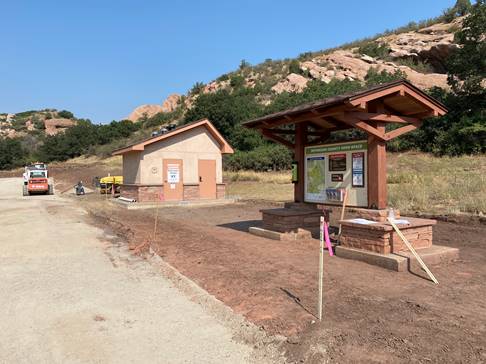 South Valley Park: South Trailhead
We are on the final stretch of construction with Road & Bridge working to prep the area around the restroom and kiosk for concrete flat work. The trail will be closed to the north, at the intersection of Coyote Song and Prairie Falcon, during the final weeks of construction when concrete and asphalt pavement will be installed. We plan to open the trailhead the week of September 21st to accommodate revegetation efforts and striping.
Virtual Learning for Spanish Speakers
As the Ranger Team adapts to virtual education programs, the Communications Team is taking the extra step to have the videos translated into Spanish. Utilizing a County contract with A&A Languages, the ESI: EcoSystem Investigation videos, designed to replace the cancelled fourth grade field trips, will now reach an even larger group of future land stewards. In fact, JCOS is partnering with the Colorado Alliance for Environmental Education, E-movement, and Thorne Nature Experience, to share this curriculum in classrooms throughout Colorado to increase environmental literacy and build a stewardship ethic within today’s youth.



 Lava Loop Trail
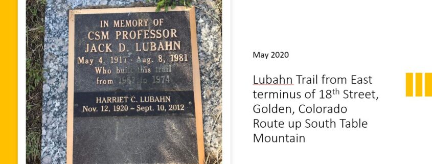 Today we have a little history lesson plus a talk about proper trail etiquette. I want to show you what happens when visitors to the parks fail to #StayOnTrail.
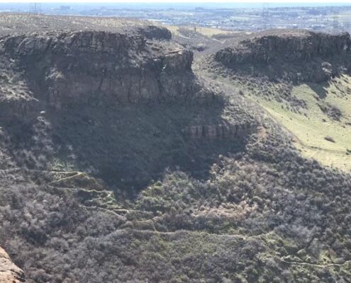 The trail took six years to finish; it was completed in 1971. To build the switchbacks, Jack had to move boulders that weighed up to two tons with just his block and tackle – truly a labor of love! The rock retaining walls on the trail stand as a tribute to his efforts.
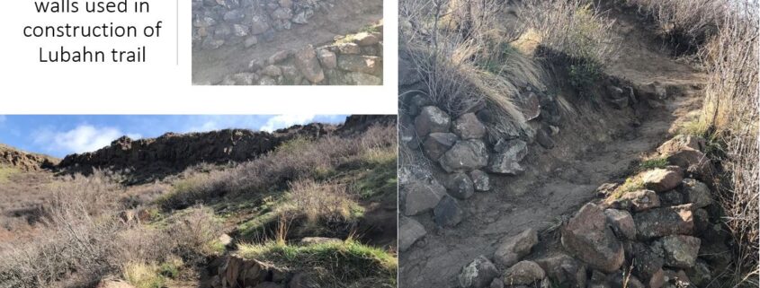 According to Colorado Lifestyle: “No one ever hikes the Lubahn Trail by itself. Instead they use it as the primary way to get part way up South Table Mountain in Golden and then use one of the many unofficial (social) trails to the top of Castle Rock (formally known as Table Rock). According to the city, this additional excursion is illegal because it traverses private property.”
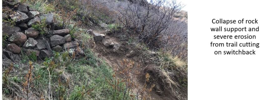
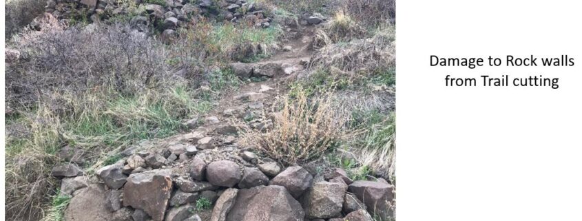 These photos show what can (and does) happen to a trail when it’s abused. Over its lifetime, trekkers and hill climbers, on foot and mountain bike, have short-cut the switchbacks, causing damage – in some places, significant damage – to the original rock work that forms the walls that line the trail. As a knowledgeable Park Visitor, I’m sure you would never do something like this, because if you did, then you would be adding to the damage on the trail.
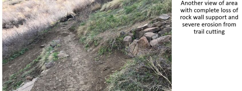 As you can see from these photos, the Lubahn Trail can be narrow in parts. Social distancing in this age of Covid is not possible when encountering others coming in the opposite direction, so have your mask ready and put it on.
  There is no clear boundary between the private and JCOS land, although there are some recently installed posts on the JCOS border along the new JCOS trail, saying that it is private land behind the posts. None of these posts are visible from where one attains the mesa top via the Lubahn trail, and no one taking the Lubahn would have any way of knowing they were on private land. It’s also not clear where the border is between city of Golden and private land.
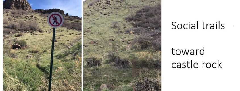 A half-block away is the new JCOS trail. It has a COVID signboard plus a newly installed map of South Table Mountain open space. There is no official parking or public restrooms. The neighborhood street is almost always packed with parked cars. Any park visitor would assume both trails are sanctioned for use. A very common hike is to go up one trail and come down the other.
 Like us at